Horseshoe Bend - Antelope Canyon Itinerary and Travel Tips
If you’re ready for a road trip to the northernmost parts of Arizona, you’ve landed in the right place for insights and tips to maximize your experiences on this trip.
Antelope Canyon is near Page, Arizona in the midst of Navajo Nation lands, about four hours north of Phoenix. You’ll find Horseshoe Bend, a meander along the Colorado River, a worthy stop along the way.
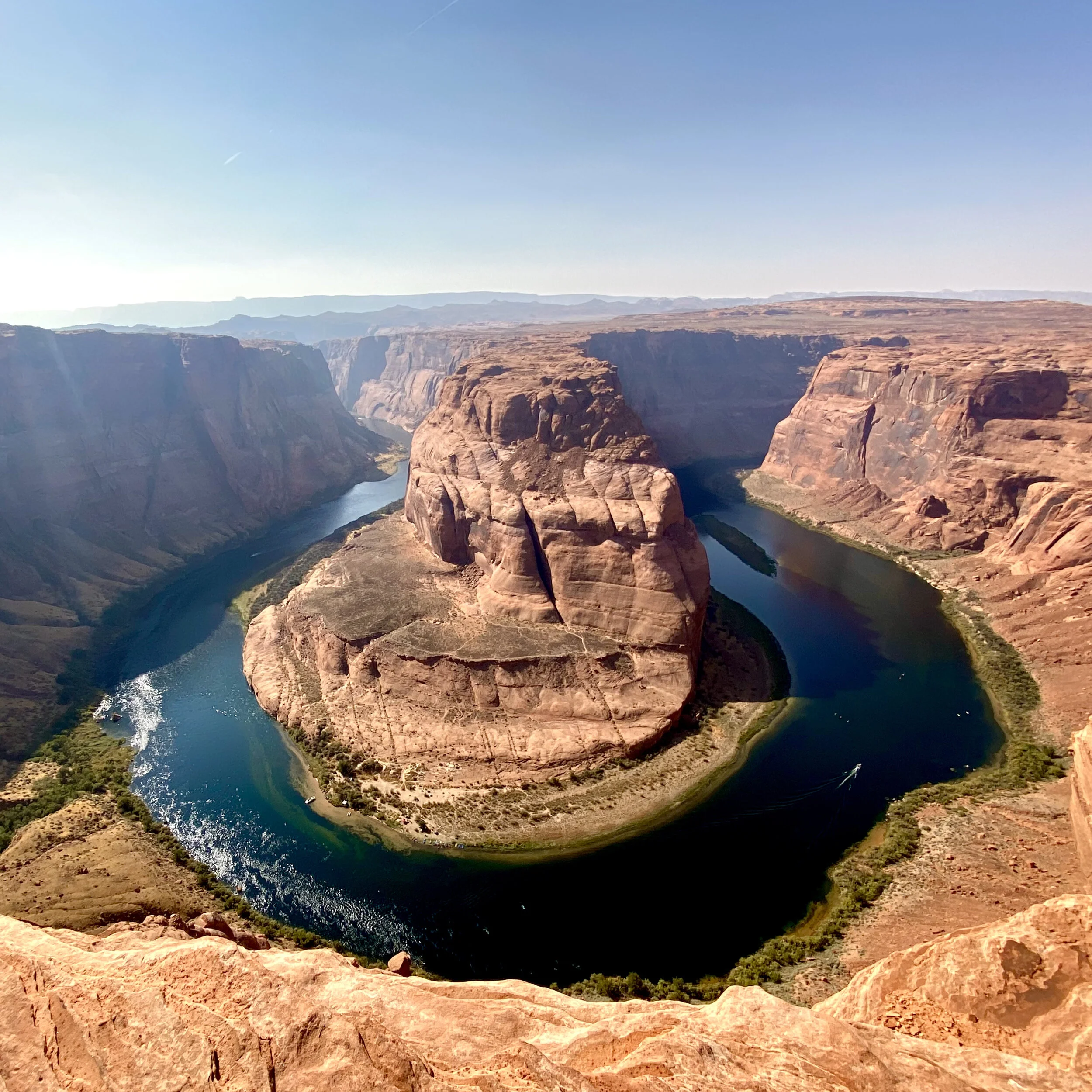
The Majestic Views of Horseshoe Bend, Arizona
Stop 1: To take in Horseshoe Bend from above, pay a $10 parking fee and follow an easy (wheelchair and stroller accessible) 1.5 mi round trip pathway to Horseshoe Bend’s rim. This bend in the Colorado River was carved 5 to 6 million years ago when the sandstone Colorado plateau lifted up and created a block to the water flow.
Over time, water does what water does and eroded the sandstone to create this magnificent bend which is considered the eastern edge of the Grand Canyon.
Along the left side of the Horseshoe and 1000 feet below on the Colorado River is Lee’s Ferry, the starting point of water activities in this area.
Stop 2: A 10 minute drive further north, on the northern edge of Arizona where it borders Utah, is the small town of Page. Get a hotel room here for your first day of adventures and take in a sunset from Wahweap overlook at nearby Glen Canyon.

Glen Canyon Dam, Arizona
The next morning (day 2), visit Lake Powell and tour Glen Canyon Dam. 186 mile long Lake Powell is one of the largest water reservoirs in the US. It is constrained by Glen Canyon Dam which was built over a 10 year span between 1956 and 1966. Page began as a camp of sorts to house workers who constructed the dam. It has since grown to a town of 7000.
I’m not a dam expert by any means, but I found this a very intriguing site. It’s a 710 foot high arch gravity dam. Like me, most of you likely have no idea what an arch gravity dam is. Let me briefly enlighten you.
The arch is designed to curve upstream which puts most of the force of the water on the canyon walls, supporting the dam and holding it in place. This results in less space and fewer materials required for construction.
There is so much beauty to be enjoyed and absorbed high above the river and yet inevitably, the desire to explore the magic of the river-level views and activities will lure you downward.

Vermillion Cliffs, Arizona
Stop 3: Mid-afternoon day 2 make your way to the Colorado River by taking a gorgeous, slow and winding, 40 mile drive from Page through Marble Canyon and the Vermillion Cliffs.
Marble Canyon and the Grand Canyon are close cousins, although technically different spaces. Marble Canyon is the section just east of the Grand Canyon’s starting point in the Horseshoe Bend area. FYI - there is no marble in Marble Canyon, just beautiful colored limestone.
Along the way, Vermillion Cliffs National Monument, a 280,000 acre natural playground, surrounds you. The cliffs are a deep red color, hence the name.
Stop 4: Another site worth exploring day 2 during the drive down to the river is Navajo Bridge.
There’s some interesting history here. The wider, newer bridge on the right replaced the narrower, historic one on the left in 1995. The historic bridge is now a pedestrian walkway that’s worth walking across (or at least onto) for some impressive views of the gorge and Colorado River 467 feet below.
This is one of only seven land crossings of the Colorado River over a 750 mile distance and was a much needed addition to the ferry crossing at Lee’s Ferry.

Navajo Bridge, Arizona
The historic bridge opened Jan 12, 1929 which enabled crossing the river here instead of driving 800 miles around the Grand Canyon (or taking the small ferry below). The original bridge was 18 feet wide and had a 40 ton weight limit. As cars and trucks became wider and heavier, a replacement was needed.
This is a beautiful overlook with the pedestrian walkway, Navajo bridge, an interpretive center with historical information, and locally made crafts for sale.
Stop 5: If you’ve come this far on this adventure, I recommend you drive another 10 minutes and stay the night of day 2 at a local motel in Marble Canyon. This way you can enjoy the drive and sights between Page and the river and still get on the river for activities early in the morning, stress free. I stayed at Cliff Dweller's Lodge during Covid. It was clean, simple, rustic and has a yummy restaurant with outdoor seating right next door.
Stop 6: If you’ve stayed the night somewhere at river level in Marble Canyon, it’s now day 3 and you’re just 15 minutes from Lee’s Ferry, the starting point of countless water adventures.
A little about the history of Lee’s Ferry before your day on the river. In the late 1800’s, expansion from Utah into Northern Arizona picked up, creating the challenge of crossing a 600 mile long, deep canyon barrier - the Colorado River.
One of the only places a wagon could reach the river from both north and south was at the mouth of Glen Canyon, and this became a natural crossing point. In 1873, Lee’s Ferry was established here, originally for river crossing and today as the launch point for river activities.
Upstream from Lee’s Ferry are calm waters and lots of opportunities for fishing, boating, kayaking and stand-up paddle boarding. Downstream, whitewater rafting adventures through the Grand Canyon take place.

Girls Trip Kayaking Horseshoe Bend, Arizona
We chose a day of kayaking which meant starting at Lee’s Ferry and travelling by boat 16 miles upstream to the base of Glen Canyon Dam. This “back haul” experience involved a fantastic 30 minute excursion via speedboat to our starting point, followed by kayaking all day back to Lee’s Ferry.
We tackled this adventure in October. The shade of the canyon during early morning hours plus the speed of the boat made it a COLD start to the day. Grandma’s quilts from the boat operator were gratefully embraced by our group.
I highly recommend our tour operator, Kayak Horseshoe Bend. Sign up in advance for a kayaking adventure starting around 8 am. You’ll finish by 4 pm and if needed, you can drive home that night.
Pro tip for those of you inspired to undertake this adventure: even though it got to be 90 degrees and sunny a few hours into the day, I wish I had brought along my puffy Patagonia jacket for the boat ride and stuffed it in my dry pack when I got in the kayak.
Stop 7: After day 3’s chilly morning boat ride, we were dropped off at the base of Glen Canyon Dam, with icicles for fingers, ready to launch our kayaks off the small sandy beach. Luckily for us, there was a group of millennials who were unphased by knee deep 45 degree water who helped us get moving.

Enjoying the serenity of a day on the Colorado River
I was surprised to learn the Colorado River is always 45-50 degrees. Which makes falling out of your kayak a cold, undesirable, and potentially life-threatening situation. We didn’t fall out. Be aware of the type of kayak you are using as some are more stable than others. Our outfitter, Kayak Horseshoe Bend, had the most stable version of hard plastic kayaks.
We each had our own kayak. There are also double kayaks available. It’s harder to coordinate steering and stability with another person onboard so stick with individual kayaks unless you have a special situation (e.g. bringing Grandma or an 8 year old).
A few on our backhaul boat had stand-up paddleboards, upon which they stowed and transported a mountain of camping gear. Their plan was to paddleboard the first day to the mid-point of the Horseshoe where there are a limited number of campsites (open during Covid). This is an out-of-the box idea that sounds great, but I wouldn’t recommend it unless you are an expert paddle-boarder and outdoors enthusiast. Big problems for you and your gear if you lose your balance and fall in the river.
During the summer months, when the river is at “high flow”, the current is faster. At this time of year, it will take the average person about 5 hours to kayak back to the endpoint. “High flow” is the result of higher electrical demand and therefore more water is released from the dam into the river.
During September to May, it’s “low flow “season so the current is slower and you have 7-8 hours on the river to enjoy the stunning river reflections, petroglyphs, horses, and Big Horn sheep grazing along the riverbank.

Surreal river reflections remind me of masterful pieces of abstract art
Stop 8: After your kayaking adventure along the Colorado River, either stay the night of day 3 at the Cliff Dwellers Lodge and take advantage of local hiking and exploration day 4, or head back to the town of Page and check in to a local motel.
There is every brand of national chain hotel/motel you can think of in Page, all perfectly fine. I rarely choose to stay at the “normal” places, because I’m always looking for more of an adventure and I like to support locally owned establishments who have been especially hard hit by Covid.
I stayed at the Red Rock Motel. It’s a 14 room, delightful, mom and pop-run, nostalgic place. There are kitchens in each unit and patios with grills out back so you can kick back and enjoy a Route 66 type experience. This gem is currently available for weekly and monthly rentals. Pro tip: you need to call owner Pamela at 928-608-0273 to make a reservation, you can’t do it online at the moment.
If you need a room for just a night or two in Page, try the Drift Inn. It’s a delightful 9 room place with common kitchen area. The Drift Inn was owned by Pam’s dad up until Covid hit and now it’s in her expanding portfolio of room offerings in Page. Love these people and this place. I will be back.

Upper Antelope Canyon with its wider paths
Stop 9: The reason you’ve returned to Page is for another “can’t miss” northern Arizona adventure on day 4: exploring Antelope Canyon. There is Upper Antelope Canyon and Lower Antelope Canyon. If you’ve come this far, definitely experience both. You need to make reservations in advance. Do an extensive Upper Canyon tour in the morning and a one hour afternoon tour of Lower Antelope Canyon in the afternoon. The tour operators I used were Dixie Ellis Lower Antelope Canyon Tours and Adventurous Antelope Canyon Tours, both highly recommended.
The canyons were closed in March 2020 and as of March 2021 they remain closed until it’s deemed Covid-safe. The canyons are narrow (difficult to social distance) and on Navajo Nation land. I visited here pre-Covid. Definitely put this on your post-Covid bucket list wherever in the world you call home.
Antelope Canyon gets its name from local Navajo stories about antelopes that grazed here during the winter months. These are slot canyons formed by rushing water that eroded the surrounding Navajo sandstone and in so doing created the smooth waves and unexpected cut-outs in the copper-colored mounds.
Publicly discovered in 1997, there have been decades of debate and hundreds of blogposts written on which is better, the Lower or Upper Canyons. Although hard to choose, and even though you should do the Upper Canyon’s lengthier tour in the morning, the Lower Canyon is my favorite.

“The Crack” as Upper Antelope Canyon is known
A favorite Antelope Canyon experience is finding and photographing light beams. Shafts of light radiate down onto the canyon floor from openings above. Most often this happens in Upper Antelope Canyon, usually in summer months when the sun is higher in the sky. Many times, these beams are like a spotlight shining down directly above you.
Upper Antelope Canyon is set at about 4000 feet elevation. A major difference versus the Lower Canyon is that you walk on a flat path versus climb into the slot canyons.
The Upper Canyons are formed in the shape of an inverted V, meaning the top is narrower and it opens up to a wider floor below.
This section of canyons is known as “The Crack” because sun filters through the cracks in the rock to create the famous light beams. Nature’s spotlight. If you want to maximize your chances of seeing a sunbeam, visit in summer from 10 am – noon.

Climbing out of Lower Antelope Canyon, Arizona
Stop 10: On the afternoon of day 4, the Lower Canyon will delight you. This canyon is formed in the shape of a V which means it’s wider at the top and narrower at the bottom. Be aware that to enter this canyon requires climbing down a series of ladders and stairways, from a small unobtrusive hole in the rocky earth to the streambed 120 feet below.
The Lower Canyon is known as “The Corkscrew”. As rushing, churning, waters flowed through the sandstone, these marvelous curves and shapes were created. It truly does feel like you are in a corkscrew as you look around in every direction.
If you simply must get back to Phoenix, you can choose to drive back after visiting Lower Antelope Canyon. If you have more time, consider adding to this itinerary with a visit to the Grand Canyon (a 3 hour drive west), or Petrified Forest (a 4 hour drive east). Check out my other blog posts for suggestions for those locations.
Summary: I loved this spiritual, majestic, spot located right here on planet Earth. I will definitely return! Next time I’ll leave time for two other nearby slot canyon areas, Canyon X and Cardiac Canyon, known to be beautiful and less crowded than Upper and Lower Antelope Canyon. And at least another day to hike and explore the Vermillion Cliffs and area around Lee’s Ferry.
You could spend weeks in this part of the world and never get bored. For those of us with a more limited amount of time, this trip (assuming drive time back and forth from Phoenix) can be done in 4 full days. Keep in mind, I rise early, keep my pace moving, and cover a lot of ground in 24 hours. There’s so much to see and do after all! If you like to sleep in, or take in nature at a more leisurely pace, give yourself a couple more days to explore.
I hope this itinerary gives you a starting point to plan your next Northern Arizona adventure. Click on most of the photos (yes, all photos are mine) for links to other sites I found useful in my planning. Feel free to reach out in the comment section below with questions. I’m happy to share whatever information I have to save you time and help you have a fantastic trip. If you’re interested in more photos and stories, check out my Instagram @travelistaliz.

See the face of “Woman in the Wind”? For more Antelope Canyon photos go to @travelistaliz on Instagram