A Perfect New Mexico Daytrip - Bandalier National Monument and Los Alamos

Tsankawi Trail Near Los Alamos, New Mexico
There are several fantastic daytrips an hour from Santa Fe that are worth your time. This is one of them.
Pro tip: If you plan to explore more than one or two National Parks, National Forests, or National Monuments over the next year, get an America the Beautiful National Parks Pass.
This $80 annual investment ($20 for seniors) will pay for itself multiple times over. You’ll benefit from having a pass for this adventure which you can buy online before your trip or on site when you arrive. If you don’t have a pass, it’s $25 per car to enter and enjoy the Monument.
Reco 1: Depart Santa Fe after an early breakfast with your hiking shoes on! Today’s adventure begins with a half hour drive to the Tsankawi trailhead for a unique petroglyph and cave hike.
Finding the trailhead can be a bit tricky as it’s unmarked along the left side of local Hwy 4.
From Santa Fe, turn off Hwy 502 onto Hwy 4 toward Bandelier. Just ¼ mile down this road, you’ll see the small parking area along the left side of the road. If you get to the stoplight, you’ve gone too far.
The Tsankawi trailhead and hike is at the furthest edge of Bandelier National Monument in its own little section of the Monument. You’ll need to have previously purchased a National Parks pass or pay cash at this roadside location.

The First of Three Tsankawi Trail Ladders
This is an easy 90 minute hike that includes climbing three ladders (the only tricky part) to access various levels of the mesa where caves and petroglyphs are found.
Aside from the ladders, the trail itself is flat. What’s so unique about this hike is the caves formerly inhabited by Pueblo Indians are carved out of white tuff, a soft rock comprised of at least 75% volcanic ash. Check out the photo here to get an idea of how easily grooves are carved into the soft stone by the Pueblos and erosion.

Soft Tuff Stone
The views from the caves along the mesa are spectacular. It’s fun to crouch down in the caves and experience the views as the much-shorter ancient dwellers of this location did.

Peeking from a Pueblo Cave Dwelling along the Tsankawi Trail
There are countless petroglyphs along the far end of the trail. I love using my imagination to interpret these drawings which reflect daily life and what was important to those who called this place home centuries ago.
Reco 2: After you’ve enjoyed Tsankawi, drive 30 minutes further (twelve miles) on Hwy 4 toward Bandelier for more exploration in Frijoles Canyon. Wrap up your visit with a picnic lunch.
There are any number of Bandelier hikes from the Monument’s entrance near the road that traverse the cliffs into the canyon below (a good cardio workout).
The easiest approach to exploring the high points of this National Monument is to drive to the Visitor Center at the base of Frijoles Canyon and take the flat Pueblo Loop trail.
You may be wondering, as did I, what the difference is between a National Park and a National Monument. National Parks are about scenic beauty and recreation. National Monuments are about preserving something of cultural or scientific significance.
Bandelier is a National Monument, the main purpose of which is to preserve the Puebloan cave dwellings located along the cliffs of this stunning canyon.

An Accessible Cave along the Pueblo Trail at Bandelier
Back to exploring. The Pueblo Loop trail is a flat, 1.4 mile loop trail that takes about an hour to complete. This leaves enough time to climb up (more ladders) and into several tuff cave cliff dwellings that have been reinforced and preserved for modern day exploration.

Views from a Cave Dwelling at Bandelier
Midway along the Pueblo Loop Trail be sure to take the offshoot to Alcove House. This will add a mile (and another 45 minutes) to your trek and allow you to experience a remote cave community 140 feet above the canyon floor.
Alcove house was once home to 25 Puebloan people. Every day, they climbed 140 feet straight up a series of ladders with water, food, and supplies to sustain daily life. While tiring, this daily vertical climb created an incredibly safe spot from unannounced visitors.. See the photo for the ladder view. I’m not afraid of heights in the least, but I took this climb very slowly. It was a little nerve-wracking but worth it.

Alcove House Ladder
There’s a kiva (Covid-closed as of 2020) in the larger cave area at the top of the ladder system where the Puebloan families lived. As you may or may not know, a kiva is an underground circular room where spiritual ceremonies were conducted. See the lower left round structure in the photo.

Alcove House view and kiva
After the hike, find a cool spot in the shade near the Visitor’s Center for a picnic lunch. There are plenty of picnic tables to spread out and enjoy this canyon’s vibe before heading out for the next stop on your itinerary.
Reco 3: Use your GPS for directions to Los Alamos from Bandelier National Monument. Be sure to download directions before you leave Santa Fe as cellular coverage is spotty at best.
There are two routes to Los Alamos, one that backtracks the way you came and the other that makes a loop through the Valles Caldera.
My advice is to take the shorter route, which will vary depending upon the weather. I took the longer Valles Caldera route because I wanted to check out the collapsed crater responsible for creating the tuff and tuffaceous rock that forms the basis for the area’s cave dwellings. 1.2 million years ago, this caldera erupted and spewed forth ash (that became tuff) as far as Kansas, 600 miles away.
The story of the caldera is more interesting than the views which are more or less just flat fields. I suppose you could hike across this area if you had plenty of time, but it didn’t seem worth it to me.
Los Alamos is worth an hour stop, even with the museums and indoor locations closed due to Covid. I parked in the Starbuck parking lot, refueled with a quick latte, and wandered along the city’s historic walking tour that begins across the street.
This is a self-paced tour that gives you the opportunity to learn more about a fascinating period in our history. Lightning speed technology development ultimately created the nuclear bomb in 28 months based on the tireless efforts of 130,000 people. This was a top-secret area that was code-named “The Manhattan Project” whose purpose was to end World War II.
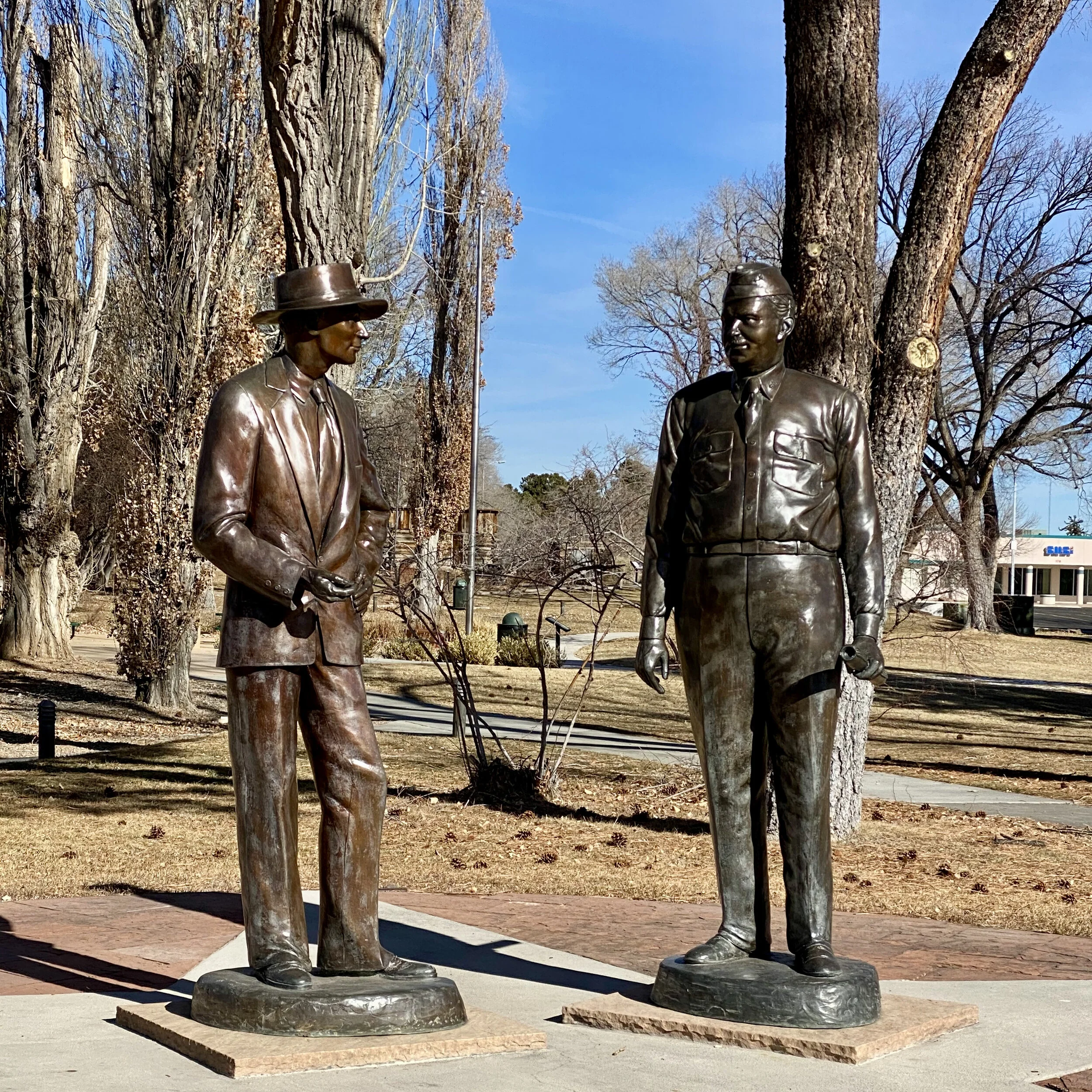
J. Robert Oppenheimer and General Leslie Groves, Key Leaders of The Manhattan Project
There are fascinating stories and sites including “Bathtub Row”, where the few houses in town with indoor plumbing and bathtubs were located, the house where well-known atomic-era scientist J. Robert Oppenheimer lived, the statue of Oppenheimer and General Leslie Groves who were the primary leaders of this project, the Eagle statue commemorating war veterans, and the Los Alamos Post Office where mail sent to Manhattan Project residents was addressed “P.O. Box 1663, Santa Fe, New Mexico” to maintain the secrecy of this location.

The Imposing Los Alamos Eagle, Dedicated to War Veterans
If you’re into collecting National Parks Passport stamps, there are three stamps available in Los Alamos. The only stamp available during my Covid-era visit was at The Manhattan Project Visitor Center - number one on the map here, across from Starbucks.
Reco 4: As you head back to Santa Fe, be sure to stop at the Senator Clinton P. Anderson Scenic Overlook on the way out of Los Alamos for some breathtaking views. It will be on the left side of Hwy 502 as you leave town. It seemingly appears out of nowhere as you round a curve on the highway. You’ll probably miss it and need to turn around.
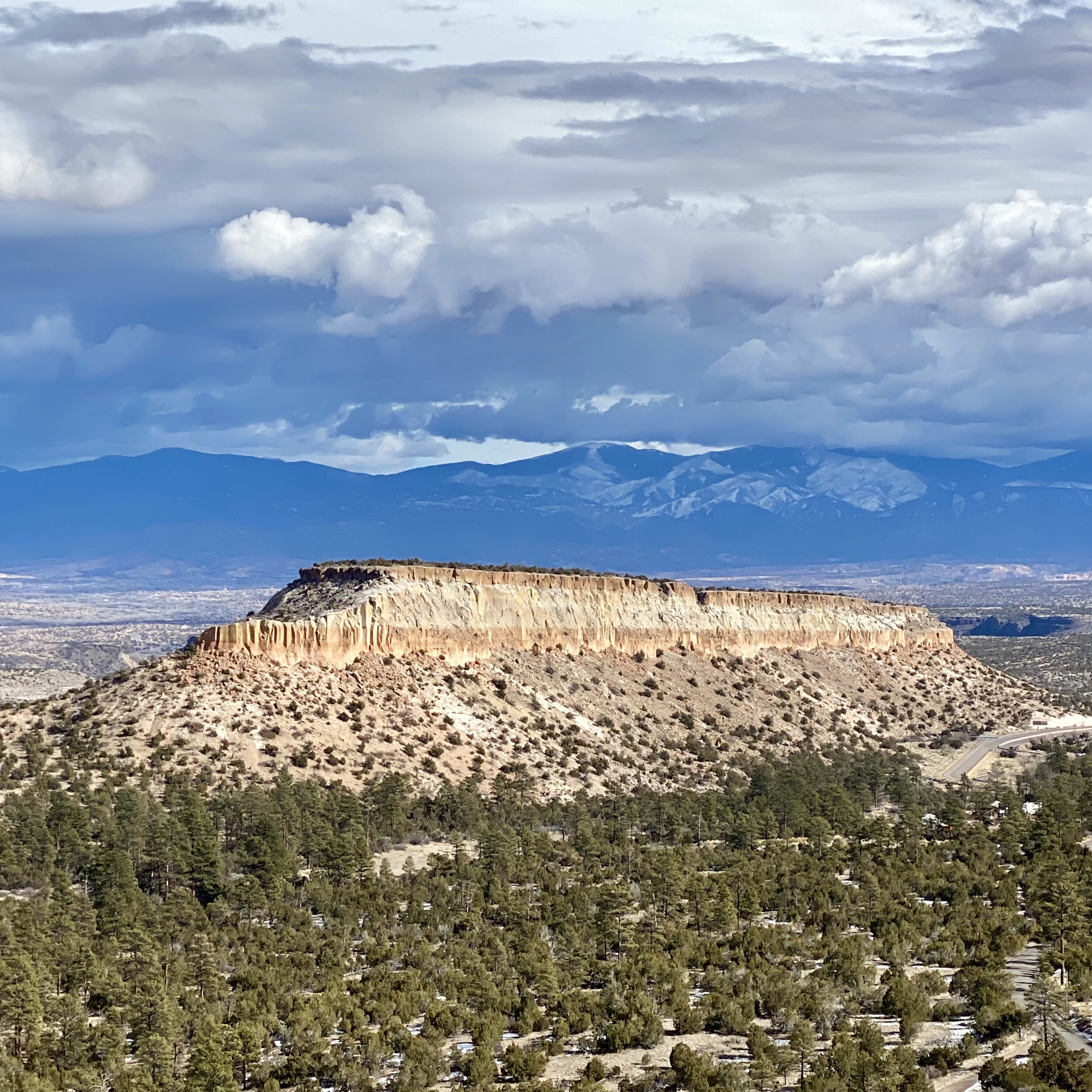
Sunny Scenic Overlook Near Los Alamos
I passed through this area twice, once in beautiful sunny conditions and once with a storm rolling in. Check out both photos.
Which view do you prefer?
Today I’m loving the storm view with the dark clouds and imposing skies.

Stormy Scenic Overlook Near Los Alamos
I hope this itinerary inspires you to consider spending one of your days in Northern New Mexico traversing this route. It’s a short drive from Santa Fe and worth it to explore both science and nature cohabitating in a unique desert environment. If you’re interested in more travel photos and stories, check out @travelistaliz on Instagram. If you have questions, please leave them in the comments below and I’ll do my best to answer. Happy Travels!